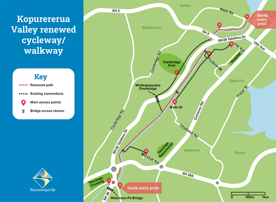
A network of tracks linking the Bethlehem area to 17th Avenue and Cameron Road through bush and alongside waterways. A 6km sealed cycleway/walkway connects The Lakes to Waihi Road near the Tauranga city centre.

Kōpūrererua Valley renewed cycle way map (94kb pdf)
Kōpūrererua Valley walkways map (159kb pdf)
Bethlehem to City via Kōpūrererua Valley (159kb pdf)
Connections from the sealed cyclepath to Marshall Avenue and Koromiko Street are only suitable for mountain bikes.
About Kōpūrererua Valley Reserve
Kōpūrererua Valley Reserve is the only inner-city reserve in Tauranga, covering 364 hectares. Running from Judea in the north to Tauriko in the south, it is bordered by the neighbourhoods of Te Reti, Gate Pā, Greerton, Westridge and Cambridge Heights.
Restoration of Kōpūrererua Valley Reserve began in early 2022, with the southern stream realigned by early 2023 and the northern stream alignment completed in April 2024 – restoring the water’s original flow through the valley.
Kōpūrererua Valley was for many years inhabited by the people of Ngāi Tamarāwaho. Remains of Puketoromiro Pā and other archaeological sites are located throughout the valley.