Liquefaction is a weakening of the ground caused by an earthquake. Sand and areas where the groundwater table is high are typically more vulnerable to liquefaction.
As much of Tauranga fits this description, we need to understand liquefaction and its potential effects for our city in the event of an earthquake.
Liquefaction mapping viewer
Causes and effects of liquefaction
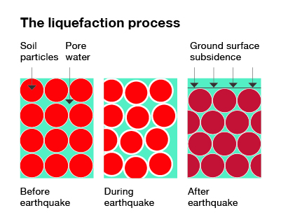
Liquefaction occurs when the energy from an earthquake causes land areas to lose strength and temporarily behave like a liquid. This specifically relates to soil that is below the ground water table and sandy or silty in composition. Following an earthquake, land re-consolidates at a lower level than before - as illustrated below. This is called subsidence.

Figure 1: The liquefaction process (taken from MBIE, Planning and Engineering Guidance for Liquefaction Prone Land, 2017)
When this occurs close to the surface, subsidence can result in cracking and distortion, and consequently cause damage to buildings and infrastructure.
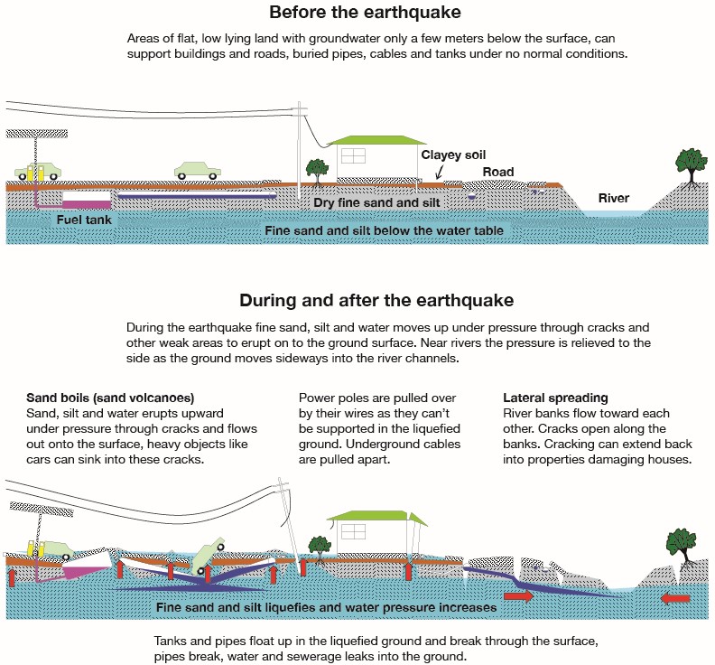
When ground liquefies close to rivers, streams, or ponds (i.e. stormwater areas), the direction of movement will likely be towards those lower areas. This is called lateral spread. It means when land moves it will follow the path of least resistance, which in turn may affect buildings and infrastructure.

Figure 2: Concept sketch showing effects of liquefaction and lateral spread hazard on the built environment (source: MBIE (2017) after IPENZ).
2020 study of liquefaction potential throughout Tauranga
We engaged a panel of recognised experts to assess the liquefaction potential throughout Tauranga. The study sought to build our existing knowledge and understanding of the risks and consequences of an earthquake.
This type of study is quite complex, as it requires an analysis of the ground shaking that might occur in an earthquake, followed by further analysis as to where and how much liquefaction may occur. This can then be translated into estimated ground damage and its likely effect on buildings and infrastructure.
Data gathering
Ground investigations were carried out throughout the city during 2019, providing the necessary data for the study. The testing involved pushing a cone-shaped probe about 10 metres into the soil, to measure soil strength, type and water content. This data was analysed to determine liquefaction potential of that site and ultimately provides a picture for the whole city. As the tests were not property specific, the study provides insight at the level of a general area only.
Results and technical reports
The results of this study are presented in maps showing liquefaction potential in Tauranga under different ground shaking scenarios along with current and future groundwater levels.
Liquefaction Hazard Assessment Report - Tauranga City Western Zone
Liquefaction Hazard Assessment Report - Tauranga City Eastern Zone
Liquefaction mapping viewer
This viewer gives you the ability to identify a general area (not a specific property) and establish the extent of possible land liquefaction based on different earthquake events, either under a current or future scenario. This future scenario takes into account possible changes to groundwater levels resulting from future sea level rise.
It is important to note that different areas are exposed to different levels of probability that the hazard will in fact occur, including the likelihood or extent of damage to land and buildings.
The reports and modelling results apply to all of Tauranga and could be superseded by site specific assessments carried out by qualified professionals who use improved or more detailed data than presented in this study.
Liquefaction mapping viewer
Historical reporting
In 2003 the Western Bay of Plenty Engineering Lifelines Group assessed the liquefaction potential of Tauranga, and the wider sub-region. This work identified where and under what circumstances liquefaction may occur at a broad regional scale.
Study report: Microzoning for earthquake hazards for the Western Bay of Plenty (2003) (11mb pdf)
Frequently asked questions
Liquefaction is a process that occurs during earthquakes where the energy from the event causes land areas to lose their strength and consequentially behave like a liquid. Following the earthquake, the land re-consolidates, and begins to settle, resulting in subsidence.
Where this process occurs close to the ground surface, large scale subsidence can occur resulting in ground settlement, cracking and distortion resulting in damage to buildings and infrastructure. For liquefaction to occur, soils need to be:
- below the ground water table,
- sandy or silty in composition (gravel and clay soils do not liquefy), or
- poorly compacted.
Where these three conditions are present close to the ground surface, a greater likelihood of liquefaction exists resulting in more likely land and property damage.
When soil starts to act like a liquid, (i.e it has liquefied), and the area is close to rivers, streams, or ponds, (i.e stormwater areas), the slopes will likely gravitate towards that lower area. This is called lateral spread.
The direction of movement is typically towards the waterways or slope. The movement of the land follows the path of the least resistance and can result in damage to buildings and infrastructure, potentially undermining their structural integrity.
In response to the Canterbury earthquakes new guidance was developed to aid in categorising land damage which occurs during an earthquake. The categories of damage are referred to as:
- none to minor,
- minor to moderate, or
- moderate to severe.
These categories are established to aid in understanding the predicted ground damage which could occur during varying earthquake events.
By applying this framework, the expectation is that in areas of ‘none to minor’ or ‘minor to moderate’ damage, following an earthquake event, damage to housing should be repairable with limited loss of use. With a stronger earthquake, the shift to 'moderate to severe increases across the city, thereby resulting in increased damage.
The Tauranga liquefaction land damage hazard and vulnerability maps identify potentially liquefaction prone areas throughout Tauranga for various sized earthquake events.
These maps have been prepared to improve our understanding of liquefaction and lateral spread following recent New Zealand earthquakes. This new data updates information that was developed in 2003.
The land damage maps are an output of technical assessments that considered Tauranga’s geology, the groundwater table as well as current and future sea level rise scenarios. The maps show predicted land damage in five potential earthquake events of various annual probability of exceedance (1-in-25 year, 1-in-100 year, 1-in-250 year, 1-in-500 year and 1-in-1000 year ground shaking events).
A total of 10 land damage maps are provided which represent the anticipated effect of liquefaction in each event based on current and future groundwater levels, while taking possible changes to groundwater levels resulting from climate change into account.
A return period, also known as a recurrence interval or probability, is an estimated average time between natural events such as earthquakes to occur.
It refers to the estimated probability of an event happening in any given year. For example, the return period of an event might be 100 years; this is otherwise expressed as a probability of it occurring in any given year, that being 1/100, or 1%.
This does not mean that if a natural event with such a return period occurs, then the next will occur in about one hundred years' time - instead, it means that, in any given year there is a 1% chance that it will happen, regardless of when the last similar event occurred.
A specific online viewer has been created that will allow you to view your general area (not your property) relative to liquefaction and lateral spread hazards.
Liquefaction mapping viewer
The purpose of the Resource Management Act (RMA) is to promote the sustainable management of natural and physical resources. Achieving this sustainable management purpose requires a number of nationally important matters to be recognised and provided for including the management of significant risks from natural hazards whilst also having particular regard to the anticipated effects of climate change.
The avoidance or mitigation of natural hazards is one of the key functions of a council in giving effect to the RMA. A similar requirement also exists for local councils under the Building Act, Local Government Act and Civil Defence Emergency Management Act.
As a result, we are required to have a good understanding of the areas potentially at risk from natural hazards to support appropriate land-use planning and development decisions. Mapping is the most accepted method to identify hazard-prone areas and provide the greatest level of certainty to the public.
The assessment builds upon and updates the previous liquefaction study completed for Tauranga and the Western Bay area in 2003.
The current assessment draws on a range of known and established knowledge, updated methods for predicting land damage as a result of liquefaction, and our learnings from the Canterbury earthquakes. It includes a range of technical reports covering Tauranga’s geology, ground information from over 3000 individual ground investigations, our long-term monitoring program of the groundwater table and a specifically built seismic shaking model for our city.
We have an obligation to make hazard information we hold available to the public under the Local Government Official Information and Meetings Act 1987.
It will be made clear on any Land Information Memorandum (LIM) requested for a property within a hazard area that we hold information in respect of liquefaction which has been derived from a liquefaction study involving modelling and technical assessments.
We are required to make information, such as the technical assessments relevant to hazards, available upon request. We cannot advise about any effect this information may have on property value or insurance.
It is recommended that professional advice is sought from a property valuation or insurance expert about any concerns you may have regarding these matters. Refer to the letter below from Insurance Council New Zealand for more information about insurance.
Information for Property Owners (125kb pdf)
The receipt of this information now allows us to improve our existing natural hazard information on liquefaction and lateral spread. We will use this information to aid in understanding potential exposure to our infrastructure within the city.
The information will also be used in the consideration of how subdivisions and new building developments are designed.
It is important to recognise that these maps are prepared to a city-wide scale and are not intended to provide assessment specific to any one property. Nor does it replace the need for site-specific investigations required for land and building development processes under the Resource Management Act and Building Act.
The maps are prepared based on an assessment of natural ground conditions and therefore do not take into account the influence of recent human activities that may influence liquefaction response (i.e. earthworks, ground improvement, foundation design), unless specifically stated within the technical reports. As such, degree of land damage may be less than predicted for a given property where liquefaction risk was addressed during landform or building foundation design.